

Map identifies opportunities to Slow the Flow
Thursday, 1 April 2021
Slow The Flow is a charity, working in the Calder Valley since 2016 to encourage and empower the community and organisations to take action on their own property and land to reduce flood risk on a local level, to 'slow the flow' in flooding events.
Many small‐scale interventions, taken together, can result in a significant amount of water being temporarily stored, or attenuated, during storm events.
These interventions help to reduce peak flows which, together with wider catchment management and traditional flood defenses, contribute to reducing the scale and damaging effects of flood events.
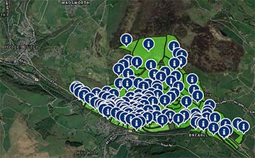
Slow The Flow's 'Opportunity Mapping' project has, so far, been focused in an area of Mytholmroyd, West Yorkshire, with intention to roll out the project further. It provides geographic detail and specific advice, giving practical suggestions for rural Natural Flood Management (NFM) and urban Sustainable Drainage Systems (SuDS).
The publicly available mapping identifies realistic locations on a field / street level of detail, where residents, businesses and organisations can contribute to flood alleviation through natural and sustainable interventions, and gives indications as to what interventions might be appropriate in those locations.
A new report on this mapping is a rare attempt to quantify the potential benefits of Sustainable Drainage Systems and Natural Flood Management on a catchment scale, based on the identified opportunities in the Mytholmroyd pilot area.
The report has been prepared with the support of partners including the SOURCE partnership, Environment Agency, Calderdale Council, and Yorkshire Water. It shows that, when extrapolated across Calderdale, almost 2 million m3 of water could possibly be attenuated using Natural Flood Management and Sustainable Drainage Systems.
Sustainable Drainage Systems and Natural Flood Management can be implemented by planting more trees, hedgerows and greening roofs; introducing swales, leaky dams and attenuation ponds into the natural landscape; adding water butts to downpipes and changing impermeable surfaces to permeable. If implemented widely enough throughout the Calder Valley, they could have a significant impact on flood mitigation in the future.
Bede Mullen, Chair of Slow The Flow, said, "This project is massively important in encouraging landowners and householders to take on small scale schemes to reduce flood risk in their own areas. While this particular map considers Mytholmroyd in West Yorkshire, lessons can be learnt here on how any landowner can make a contribution to reducing flood risk.
"Slow the Flow will look for resources to carry out SuDS/NFM opportunities mapping across a wider area, to build on this pilot project. Meanwhile, climate change threatens increasingly severe flooding.
"The new report highlights that all Natural Flood Management and Sustainable Drainage Systems opportunities, no matter what scale, should be converted into 'slow the flow' features as a matter of urgency."
Bill Blackledge, MD of 2B Landscape Consultancy, who contributed to both mapping study and report, said, "These calculations suggest that residents, land owners, businesses, organisations and developers in Calderdale could help to reduce flood impacts by implementing Sustainable Drainage Systems and Natural Flood Management on their land holdings."
Scott Patient, Calderdale Council Cabinet member for Climate Change and Resilience, said, "Slow The Flow has been instrumental locally in encouraging the community to help make the valley more flood resilient by volunteering their time to help build interventions. This project builds on their work, to go a step further and encourage local people to volunteer their land, and take the initiative to implement their own projects.
"I hope people will take a closer look at the findings of this report, explore the map and consider how they can help"
More info
Natural Flood Management (NFM) and Sustainable Drainage Systems (SuDS) Map